
Latest
Maps
We specialise in cartography and offer a unique service to produce Illustrated Maps. In these, anything is possible – from a simple digital road map to a hand-drawn aerial version showing every building in a city.

Hand drawn illustrated map of the Waterside wedding venue
From a complex rough sketch from the client I produced this hand drawn map of the Waterside wedding venue showing in detail what sort of entertainments were available for guests on the night.

Illustrated map of the links course Carnoustie
Illustrated map of the golf course and local town of Carnoustie.
Illustration and design work for wayfinding project in Halesworth Suffolk
New illustrations and illustrated maps for a wayfinding project for the town of Halesworth in Suffolk. The project included reworking walking routes which leave from a central point in the town
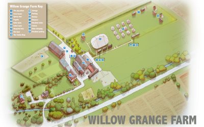
Illustrated map of Willow Grange Farm
Illustrated map of the wedding venue Willow Grange Farm near Cambridge. Work was hand-drawn and then coloured up in photoshop and then annotated in illustrator.
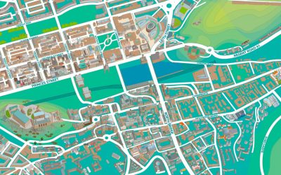
New illustrated maps of Edinburgh
New illustrated map of Edinburgh. Digital map illustration of the central area of Edinburgh featuring both the old and new towns. Edinburgh is Scotland's compact, hilly capital. It has a medieval Old Town and elegant Georgian New Town with gardens and neoclassical...
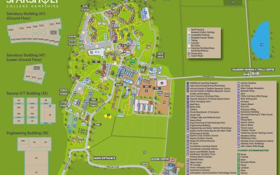
New illustrated map of Sparsholt College
Map showing the key buildings, roads and key for Sparsholt College commissioned by Latitude Maps, London.
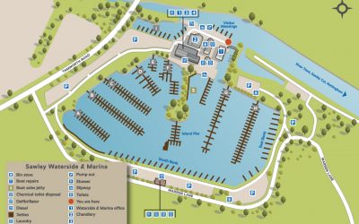
Illustrated maps for British Waterways/Aquavista
One of a series of 36 illustrative maps for British Waterways/Aquavista. The illustrations feature the marinas owned throughout the UK, I also designed a series of icons to be used throughout in the annotations. The work was commissioned by 3-sixty in Bristol
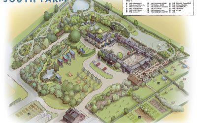
Illustrated map of South Farm
Combination of hand drawn and digital image for the wedding venue South Farm. The original drawing was produced using drone images and my own photographs. This was subsequently coloured up in Photoshop.
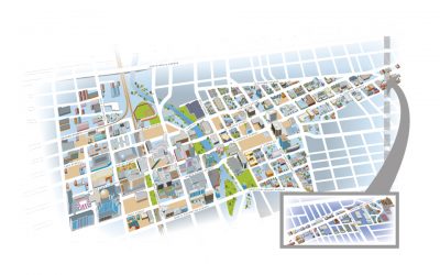
Illustrated map of Reno
Illustrated map of the city of Reno Nevada for Lovell Johns. The brief was to produce a detailed isometric map of the area. The problems encountered were showing the skyscrapers without hiding roads behind them. The bright colours reflect the vibrant nature of the...