
Services
Illustration
Maps
We specialise in cartography and offer a unique service to produce Illustrated Maps. In these, anything is possible – from a simple digital road map to a hand-drawn aerial version showing every building in a city.
General Illustration
Illustration
Richard Bowring Illustration
Illustration in all its forms is a large part of our business, we work in both traditional and digital media, from a simple line drawing to a complex computer created illustration.
Project Brief
Tell me about your project and vision.
Project Planning
Plan and budget with your input at the forefront.
Project Execution
I’ll make your vision a reality.

Think, Imagine, Commission
Your business is unique and your illustrations should demonstrate this. Ditch the same stock images that other people are using. Commission your own commercial illustrations.
01
Think about your illustration needs.
02
Imagine how they will look.
03
Commission me to make your vision a reality.
latest Illustration work
Illustration Blog
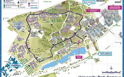
New illustrated maps for Nottingham University
Illustrated maps of the three campuses that make up Nottingham University
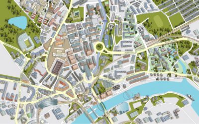
Illustrated map of Newcastle City Centre
Aerial view of the city of Newcastle showing all buildings, roads and services.
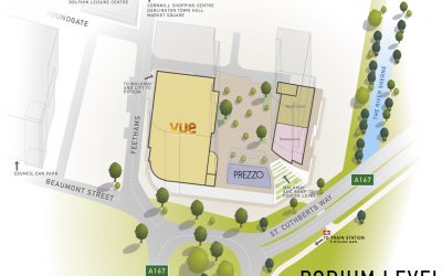
Illustrated map of the Feethams Shopping development in Darlington
Working from Architects drawings and site photography my brief was to work out the eventual layout of the shopping development in 3D, allowing for the inclusion of information regarding which businesses are to occupy the vacant spaces within.
Get Started
Let’s Work Together

Illustration in all its forms is a large part of our business, we work in both traditional and digital media, from a simple line drawing to a complex computer created illustration.