
Services
Illustration
Maps
We specialise in cartography and offer a unique service to produce Illustrated Maps. In these, anything is possible – from a simple digital road map to a hand-drawn aerial version showing every building in a city.
General Illustration
Illustration
Richard Bowring Illustration
Illustration in all its forms is a large part of our business, we work in both traditional and digital media, from a simple line drawing to a complex computer created illustration.
Project Brief
Tell me about your project and vision.
Project Planning
Plan and budget with your input at the forefront.
Project Execution
I’ll make your vision a reality.

Think, Imagine, Commission
Your business is unique and your illustrations should demonstrate this. Ditch the same stock images that other people are using. Commission your own commercial illustrations.
01
Think about your illustration needs.
02
Imagine how they will look.
03
Commission me to make your vision a reality.
latest Illustration work
Illustration Blog

Illustrations for colouring book of Ely for Kings school.
Colouring book project focussing on the fine buildings of the City of Ely and The Kings School.
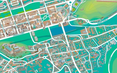
New illustrated maps of Edinburgh
New illustrated map of Edinburgh. Digital map illustration of the central area of Edinburgh featuring both the old and new towns. Edinburgh is Scotland's compact, hilly capital. It has a medieval Old Town and elegant Georgian New Town with gardens and neoclassical...
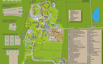
New illustrated map of Sparsholt College
Map showing the key buildings, roads and key for Sparsholt College commissioned by Latitude Maps, London.
Get Started
Let’s Work Together

Illustration in all its forms is a large part of our business, we work in both traditional and digital media, from a simple line drawing to a complex computer created illustration.